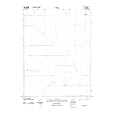
2010 Map of Arickaree
USGS Topo · Published 2010About this map
Arickaree and the surrounding rural high plains of Washington County are defined by a strict orthogonal grid of county roads that carve the landscape into square sections. This 2010 survey illustrates a sparsely populated agricultural environment where the small settlement of Arickaree sits at a crossroads, while the locality of Wiladel occupies the northern edge of the map. The natural hydrology of Gordon Creek provides the primary break in the geometric road pattern, its meandering course cutting through the southern half of the quadrangle. High points like Payne Hill punctuate the terrain, which is otherwise dominated by the systematic layout of routes such as County Rd LL and County Rd-6. This map offers a clear view of the modern rural infrastructure used to manage this vast stretch of eastern Colorado.
Find a feature on this map
18 named features on this map. Tap any name to fly to it.
Don’t see what you’re looking for? This feature index may not catch every label — zoom into the map to look around manually.
Map Details
Editions of this 2010 Arickaree Map
This is the sole edition of this map. No revisions or reprints were ever made.
Other maps of this area

1954 · Limon
USGS Topo · 1:250,000

1957 · Limon
USGS Topo · 1:250,000

1958 · Limon
USGS Topo · 1:250,000

1977 · Thurman
USGS Topo · 1:24,000
1977 · Elba SW
USGS Topo · 1:24,000

1977 · Arickaree
USGS Topo · 1:24,000

1977 · Elba SE
USGS Topo · 1:24,000

1977 · Anton SE
USGS Topo · 1:24,000

1977 · Cope SW
USGS Topo · 1:24,000
1978 · Anton
USGS Topo · 1:24,000