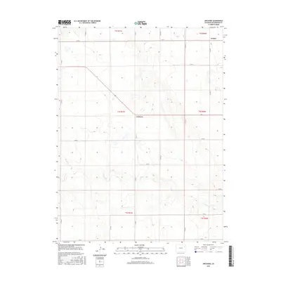
2016 Map of Arickaree
USGS Topo · Published 2016About this map
The settlement of Arickaree sits at the center of this High Plains landscape, where the traditional grid of county roads meets the winding path of Gordon Cr. This 2016 survey documents a sparsely populated region of Washington County defined by expansive sections of the Public Land Survey System, including t4s r51w and t4s r50w. The map illustrates a highly organized rural infrastructure, where routes like Co Rd 12 and Co Rd 4 define the boundaries of large agricultural tracts.
Find a feature on this map
23 named features on this map. Tap any name to fly to it.
Don’t see what you’re looking for? This feature index may not catch every label — zoom into the map to look around manually.
Map Details
Editions of this 2016 Arickaree Map
This is the sole edition of this map. No revisions or reprints were ever made.
Other maps of this area

1954 · Limon
USGS Topo · 1:250,000

1957 · Limon
USGS Topo · 1:250,000

1958 · Limon
USGS Topo · 1:250,000

1977 · Thurman
USGS Topo · 1:24,000
1977 · Elba SW
USGS Topo · 1:24,000

1977 · Arickaree
USGS Topo · 1:24,000

1977 · Elba SE
USGS Topo · 1:24,000

1977 · Anton SE
USGS Topo · 1:24,000

1977 · Cope SW
USGS Topo · 1:24,000
1978 · Anton
USGS Topo · 1:24,000