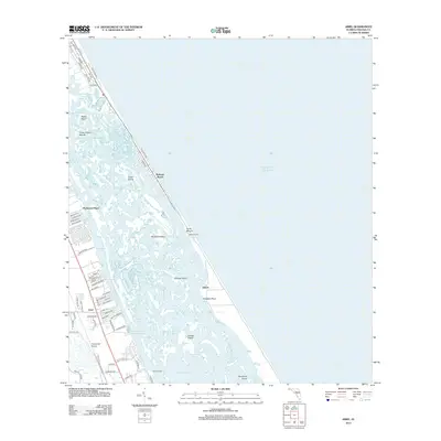
2012 Map of Ariel
USGS Topo · Published 2012About this map
Mosquito Lagoon dominates this coastal landscape, separating the mainland settlements from the slender barrier islands along the Atlantic Ocean. In the early 21st century, this corridor shows a distinct contrast between the developed residential streets of Ariel and the preserved, marshy reaches of Canaveral National Seashore. The map highlights several points of historical and archaeological interest, including the ancient Turtle Mound and the site of Eldora tucked along the lagoon shore. The labyrinth of waterways, such as Bottle Island Creek and Brickhouse Cove, reveals the complex estuarine environment that has long defined local navigation and lifestyle. To the south, the Highlander Airport and the Riverwood Park Campground Marina reflect the area's modern ties to recreation and private aviation, while northern settlements like Bethune Beach trace the shoreline of the Volusia County coast.
Find a feature on this map
78 named features on this map. Tap any name to fly to it.
Don’t see what you’re looking for? This feature index may not catch every label — zoom into the map to look around manually.
Map Details
Editions of this 2012 Ariel Map
This is the sole edition of this map. No revisions or reprints were ever made.
Other maps of this area

1937 · Port Orange
USGS Topo · 1:48,000

1943 · Port Orange
USGS Topo · 1:62,500

1944 · Port Orange
USGS Topo · 1:62,500

1949 · Oak Hill
USGS Topo · 1:24,000

1949 · Pardon Island
USGS Topo · 1:24,000

1950 · Maytown
USGS Topo · 1:24,000

1950 · Ariel
USGS Topo · 1:24,000

1950 · Edgewater
USGS Topo · 1:24,000
1952 · Pardon Island
USGS Topo · 1:24,000

1954 · Daytona Beach
USGS Topo · 1:250,000