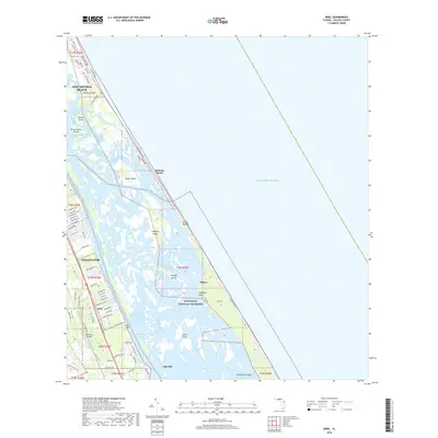
2018 Map of Ariel
USGS Topo · Published 2018About this map
Canaveral National Seashore dominates the eastern coastline of this map, protecting a delicate network of barrier islands and estuaries. The area is defined by the Intracoastal Waterway and the expansive Mosquito Lagoon, which separates the mainland from the Atlantic coast. Notable archaeological and historic sites are peppered throughout this aquatic landscape, including Turtle Mound and the settlement of Eldora near Pumpkin Point.
Find a feature on this map
85 named features on this map. Tap any name to fly to it.
Don’t see what you’re looking for? This feature index may not catch every label — zoom into the map to look around manually.
Map Details
Editions of this 2018 Ariel Map
This is the sole edition of this map. No revisions or reprints were ever made.
Other maps of this area

1937 · Port Orange
USGS Topo · 1:48,000

1943 · Port Orange
USGS Topo · 1:62,500

1944 · Port Orange
USGS Topo · 1:62,500

1949 · Oak Hill
USGS Topo · 1:24,000

1949 · Pardon Island
USGS Topo · 1:24,000

1950 · Maytown
USGS Topo · 1:24,000

1950 · Ariel
USGS Topo · 1:24,000

1950 · Edgewater
USGS Topo · 1:24,000
1952 · Pardon Island
USGS Topo · 1:24,000

1954 · Daytona Beach
USGS Topo · 1:250,000