
1973 Map of Arinosa SE
USGS Topo · Published 1977About this map
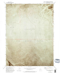
The Wendover Air Force Range dominates this landscape in the early 1970s, illustrating the intersection of military utility and the austere environments of the western deserts. Located in Tooele County, the terrain is characterized by a massive expanse of Mud Flat, a topographical feature that provided a naturally level and expansive surface suitable for aviation and ordnance testing. To the east, the topography shifts slightly as Sand Dunes appear, breaking the uniformity of the flats. This orthophotomap, based on 1972 aerial photography, provides a rare visual record of the physical state of the range during the Cold War era. The absence of traditional settlements or infrastructure highlights the isolation of this high-desert basin, where the primary human presence was defined by the requirements of the Department of the Interior and military operations.
Find a feature on this map
3 named features on this map. Tap any name to fly to it.
Don’t see what you’re looking for? This feature index may not catch every label — zoom into the map to look around manually.
Map Details
Editions of this 1973 Arinosa SE Map
This is the sole edition of this map. No revisions or reprints were ever made.
Other maps of this area

1953 · Tooele
USGS Topo · 1:250,000

1955 · Tooele
USGS Topo · 1:250,000

1973 · Knolls SW
USGS Topo · 1:24,000

1973 · Arinosa
USGS Topo · 1:24,000

1973 · Arinosa SW
USGS Topo · 1:24,000

1973 · Arinosa NE
USGS Topo · 1:24,000

1973 · Wildcat Mountain NW
USGS Topo · 1:24,000

1973 · Barro
USGS Topo · 1:24,000

1973 · Gold Hill 1 NE
USGS Topo · 1:24,000
1973 · South of Arinosa SW
USGS Topo · 1:24,000