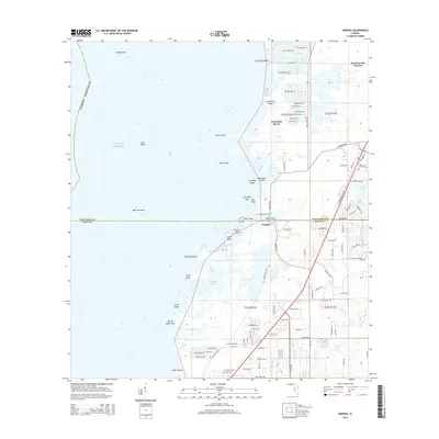
2015 Map of Aripeka
USGS Topo · Published 2015About this map
The coastal village of Aripeka sits at the intersection of the Hernando Co Pasco Co line, serving as a gateway to a complex labyrinth of marshy islands and tidal inlets. This 2015 U.S. Geological Survey record illustrates the contrast between the residential canal developments of Hernando Beach and Weekiwachee Gardens and the largely undeveloped wetlands to the south. The Gulf coast here is defined by a dense cluster of named landforms such as Indian Key, Cabbage Island, and Palm Island, which buffer the mainland from the Gulf of Mexico. Navigation and local geography are shaped by water passages like The Cutoff and Fillman Bayou. Inland, the landscape transitions from these low-lying coastal fringes toward the freshwater basin of Hunters Lake, revealing the modern road networks that connect these isolated fishing and residential communities to the larger region.
Find a feature on this map
109 named features on this map. Tap any name to fly to it.
Don’t see what you’re looking for? This feature index may not catch every label — zoom into the map to look around manually.
Map Details
Editions of this 2015 Aripeka Map
This is the sole edition of this map. No revisions or reprints were ever made.
Other maps of this area

1954 · Port Richey
USGS Topo · 1:24,000

1954 · Fivay
USGS Topo · 1:24,000

1954 · Aripeka
USGS Topo · 1:24,000

1954 · Bayport
USGS Topo · 1:24,000

1954 · Weekiwachee Springs
USGS Topo · 1:24,000

1954 · Port Richey NE
USGS Topo · 1:24,000

1955 · Plant City
USGS Topo · 1:250,000

1958 · Plant City
USGS Topo · 1:250,000

1959 · Plant City
USGS Topo · 1:250,000

1964 · Plant City
USGS Topo · 1:250,000