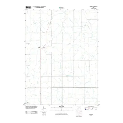
2010 Map of Arispe
USGS Topo · Published 2010About this map
Arispe serves as the central hub of this Iowa landscape, where the Arispe Post Office marks the heart of the community. The terrain is defined by a dense network of waterways, including the winding East Fork Grand River, Indian Creek, and Twelvemile Creek. This survey captures the rural character of Union County, structured by a systematic grid of roads like Nighthawk Ave and Pheasant Ave. Local history is anchored by the presence of the Abel Cemetery in the northeast and Beyer Cemetery in the southwest, providing vital points of reference for genealogists. The map illustrates how the settlement patterns and agricultural property lines are deeply influenced by the paths of Sand Creek and Hackberry Creek as they traverse the countryside.
Find a feature on this map
31 named features on this map. Tap any name to fly to it.
Don’t see what you’re looking for? This feature index may not catch every label — zoom into the map to look around manually.
Map Details
Editions of this 2010 Arispe Map
This is the sole edition of this map. No revisions or reprints were ever made.
Other maps of this area

1951 · Afton
USGS Topo · 1:62,500

1954 · Omaha
USGS Topo · 1:250,000

1955 · Nebraska City
USGS Topo · 1:250,000

1957 · Nebraska City
USGS Topo · 1:250,000

1957 · Omaha
USGS Topo · 1:250,000

1958 · Omaha
USGS Topo · 1:250,000

1958 · Nebraska City
USGS Topo · 1:250,000

1980 · Creston East
USGS Topo · 1:24,000
1981 · Arispe
USGS Topo · 1:24,000
1981 · Shannon City
USGS Topo · 1:24,000