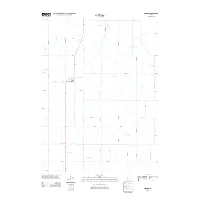
2013 Map of Arispe
USGS Topo · Published 2013About this map
The town of Arispe sits at the intersection of local routes like Dutcher Ave and Forbes St, serving as a centralized point in a landscape defined by its rolling drainage systems. This agrarian region is carved by the Grand River and its significant tributary, the E Fork Grand River, which wind through the southern and eastern portions of the quadrangle. The survey captures a network of rural roads named for local fauna, including Nighthawk Ave, Pheasant Ave, and Quail Ave, which provide access to the surrounding farmsteads. These corridors cross several named waterways such as Indian Cr and Twelvemile Cr, illustrating the relationship between the rectangular survey grid and the natural topography of Union County. Along the southern border, Ringgold Union St marks the political boundary, where the headwaters of Hackberry Cr and Squaw Cr begin their descent.
Find a feature on this map
47 named features on this map. Tap any name to fly to it.
Don’t see what you’re looking for? This feature index may not catch every label — zoom into the map to look around manually.
Map Details
Editions of this 2013 Arispe Map
This is the sole edition of this map. No revisions or reprints were ever made.
Other maps of this area

1951 · Afton
USGS Topo · 1:62,500

1954 · Omaha
USGS Topo · 1:250,000

1955 · Nebraska City
USGS Topo · 1:250,000

1957 · Nebraska City
USGS Topo · 1:250,000

1957 · Omaha
USGS Topo · 1:250,000

1958 · Omaha
USGS Topo · 1:250,000

1958 · Nebraska City
USGS Topo · 1:250,000

1980 · Creston East
USGS Topo · 1:24,000
1981 · Arispe
USGS Topo · 1:24,000
1981 · Shannon City
USGS Topo · 1:24,000