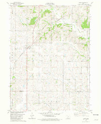
1981 Map of Arispe
USGS Topo · Published 1981About this map
Arispe serves as the primary hub of this Iowa landscape, situated along the Chicago and North Western rail line that cuts diagonally across the northern terrain. The geography is defined by a dense network of waterways draining southward, including the Grand River, Twelvemile Creek, and Sand Creek. These streams create a rolling topography across townships such as Sand Creek and Tingley, where the land begins its descent toward the Missouri border.
Find a feature on this map
21 named features on this map. Tap any name to fly to it.
Don’t see what you’re looking for? This feature index may not catch every label — zoom into the map to look around manually.
Map Details
Editions of this 1981 Arispe Map
This is the sole edition of this map. No revisions or reprints were ever made.
Other maps of this area

1951 · Afton
USGS Topo · 1:62,500

1954 · Omaha
USGS Topo · 1:250,000

1955 · Nebraska City
USGS Topo · 1:250,000

1957 · Nebraska City
USGS Topo · 1:250,000

1957 · Omaha
USGS Topo · 1:250,000

1958 · Omaha
USGS Topo · 1:250,000

1958 · Nebraska City
USGS Topo · 1:250,000

1980 · Creston East
USGS Topo · 1:24,000
1981 · Shannon City
USGS Topo · 1:24,000
1981 · Tingley NE
USGS Topo · 1:24,000