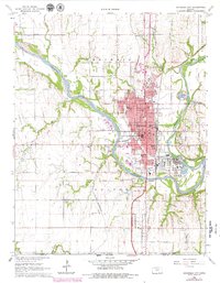
1965 Map of Arkansas City
USGS Topo · Published 1979About this map
The confluence of the Arkansas River and the Walnut River anchors this landscape in southern Kansas, where the urban grid of Arkansas City expands across the high ground between the waterways. The area is a vital rail hub, intersected by the Atchison Topeka and Santa Fe, the St Louis San Francisco, and the Midland Valley Missouri Pacific railroads. This 1960s-era survey reveals a densely packed community featuring numerous neighborhood schools such as Adams Sch and Jefferson Sch, as well as Central Junior College. Beyond the city limits, the landscape transitions into the Geuda Springs Oil Field and the Canfield Oil Field, highlighting the region's industrial foundations. A significant historical marker, the Old Indian Treaty Boundary, cuts through Bolton township, serving as a reminder of earlier territorial divisions.
Find a feature on this map
49 named features on this map. Tap any name to fly to it.
Don’t see what you’re looking for? This feature index may not catch every label — zoom into the map to look around manually.
Map Details
Editions of this 1965 Arkansas City Map
3 editions found
Other maps of this area

1889 · Burden
USGS Topo · 1:125,000

1890 · Wellington
USGS Topo · 1:125,000

1935 · Kaw
USGS Topo · 1:62,500

1955 · Wichita
USGS Topo · 1:250,000

1955 · Enid
USGS Topo · 1:250,000

1958 · Enid
USGS Topo · 1:250,000

1958 · Wichita
USGS Topo · 1:250,000

1963 · Kaw City NW
USGS Topo · 1:24,000

1965 · Silverdale
USGS Topo · 1:24,000

1965 · Arkansas City
USGS Topo · 1:24,000