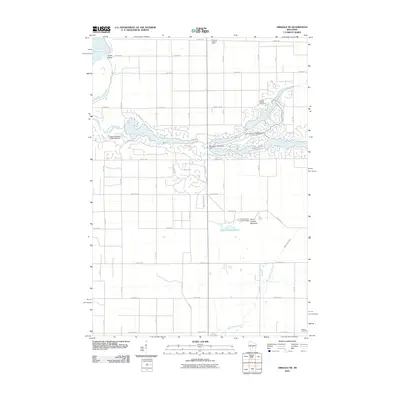
2010 Map of Arkdale NE
USGS Topo · Published 2010About this map
Fourteenmile Creek defines the central character of this Adams County landscape, where a series of water management projects have created a recreational and residential corridor. The 2010 geography is marked by the Sherwood 3WR1125 Dam and the Lake Camelot 3WR324 Dam, which help regulate the flow through the township's eastern reaches. Further downstream, the Lake Arrowhead 3WR1493 Dam anchors another significant water body, with the surrounding area divided into numerous residential drives and trails, such as Rapids Trl and Rain Dance Trl.
Find a feature on this map
48 named features on this map. Tap any name to fly to it.
Don’t see what you’re looking for? This feature index may not catch every label — zoom into the map to look around manually.
Map Details
Editions of this 2010 Arkdale NE Map
This is the sole edition of this map. No revisions or reprints were ever made.
Other maps of this area

1955 · Green Bay
USGS Topo · 1:250,000

1957 · Wisconsin Rapids
USGS Topo · 1:48,000

1957 · Whiting
USGS Topo · 1:48,000

1958 · Arkdale
USGS Topo · 1:48,000

1958 · Coloma
USGS Topo · 1:48,000

1967 · Roche A Cri
USGS Topo · 1:24,000

1967 · Arkdale NE
USGS Topo · 1:24,000

1967 · Wisconsin Rapids
USGS Topo · 1:62,500
1967 · Arkdale
USGS Topo · 1:24,000

1968 · Coloma NW
USGS Topo · 1:24,000