
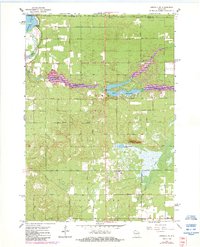
1967 Map of Arkdale NE
USGS Topo · Published 1969About this map
The Petenwell Flowage and the surrounding township of Rome define this central Wisconsin landscape during the late 1960s. Fed by the waters of Fourteenmile Creek, the artificial Lake Sherwood emerges as a prominent recreational centerpiece, complete with a Gaging Station and nearby Ski Lifts and a Ski Jump near Dorro Couche Lake. This era shows a transition from traditional rural patterns toward seasonal recreation, as evidenced by the proximity of the Dorro Couche Lookout Tower to these newer leisure developments.
Find a feature on this map
31 named features on this map. Tap any name to fly to it.
Don’t see what you’re looking for? This feature index may not catch every label — zoom into the map to look around manually.
Map Details
Editions of this 1967 Arkdale NE Map
2 editions found
Other maps of this area

1955 · Green Bay
USGS Topo · 1:250,000

1957 · Wisconsin Rapids
USGS Topo · 1:48,000

1957 · Whiting
USGS Topo · 1:48,000

1958 · Arkdale
USGS Topo · 1:48,000

1958 · Coloma
USGS Topo · 1:48,000

1967 · Roche A Cri
USGS Topo · 1:24,000

1967 · Wisconsin Rapids
USGS Topo · 1:62,500
1967 · Arkdale
USGS Topo · 1:24,000

1968 · Coloma NW
USGS Topo · 1:24,000

1968 · Coloma SW
USGS Topo · 1:24,000