
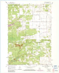
1968 Map of Coloma NW
USGS Topo · Published 1971About this map
Holliday Cemetery and Coloma-Leola Cemetery stand as quiet landmarks within this rural landscape of central Wisconsin during the late 1960s. The terrain is defined by a dense grid of alphabetized and named thoroughfares, such as Akron Drive and Apache Avenue, which segment the townships of Rome, Leola, and Colburn. Waterways including Fourteenmile Creek and the winding Roche a Cri Creek flow through the marshy lowlands and wooded tracts, illustrating the drainage patterns that shaped local land use. Distinctive geological features like Owens Rock and Keystone Rock provide vertical contrast to the surrounding flats. This survey, conducted as modern roadway planning began to formalize the rural grid, offers a precise record of property divisions and natural features before further residential and agricultural development altered the character of the Adams County and Portage County borderlands.
Find a feature on this map
30 named features on this map. Tap any name to fly to it.
Don’t see what you’re looking for? This feature index may not catch every label — zoom into the map to look around manually.
Map Details
Editions of this 1968 Coloma NW Map
2 editions found
Other maps of this area

1955 · Green Bay
USGS Topo · 1:250,000

1957 · Wisconsin Rapids
USGS Topo · 1:48,000

1957 · Whiting
USGS Topo · 1:48,000

1958 · Arkdale
USGS Topo · 1:48,000

1958 · Coloma
USGS Topo · 1:48,000

1967 · Roche A Cri
USGS Topo · 1:24,000

1967 · Arkdale NE
USGS Topo · 1:24,000

1967 · Wisconsin Rapids
USGS Topo · 1:62,500

1968 · Coloma SW
USGS Topo · 1:24,000

1968 · Coloma
USGS Topo · 1:24,000