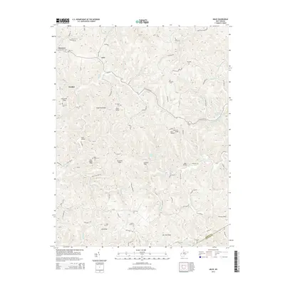
2014 Map of Arlee
USGS Topo · Published 2014About this map
Mohrtown and Arlee anchor this West Virginia landscape, defined by a complex network of ridges and hollows along the Mason and Putnam county line. The terrain is characterized by prominent landforms such as Mt Carmel Ridge and Sevenmile Ridge, where local life followed the winding path of Sixteenmile Cr and its many tributaries. This area is dense with family-named landmarks and small burial grounds, including Barton Chapel Cem and Mtn Valley Cem, indicating a long-established rural community pattern. The northern portion of the map includes a section of the Cornstalk Reservation Area, emphasizing the importance of protected lands in this part of the state. Narrow roads like Little Sixteen Rd and CR 29 connect the scattered settlements, tracing the natural contours of the deep hollows like Barn Hollow and Potts Hollow.
Find a feature on this map
84 named features on this map. Tap any name to fly to it.
Don’t see what you’re looking for? This feature index may not catch every label — zoom into the map to look around manually.
Map Details
Editions of this 2014 Arlee Map
This is the sole edition of this map. No revisions or reprints were ever made.
Other maps of this area

1906 · Glenwood
USGS Topo · 1:62,500

1906 · Winfield
USGS Topo · 1:62,500

1908 · Glenwood
USGS Topo · 1:62,500

1908 · Winfield
USGS Topo · 1:62,500

1908 · Ravenswood
USGS Topo · 1:62,500

1908 · Point Pleasant
USGS Topo · 1:62,500

1926 · Ravenswood
USGS Topo · 1:62,500

1926 · Point Pleasant
USGS Topo · 1:62,500

1928 · Ravenswood
USGS Topo · 1:62,500

1929 · Point Pleasant
USGS Topo · 1:62,500