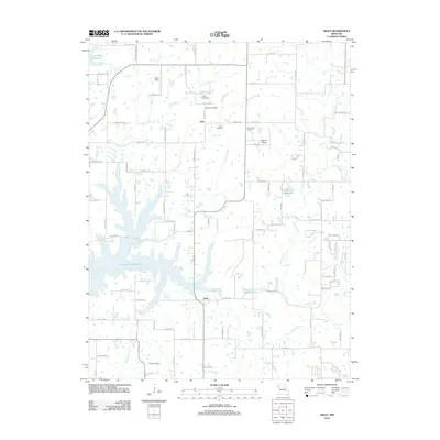
2012 Map of Arley
USGS Topo · Published 2012About this map
The Smithville Reservoir dominates the western landscape of this Missouri quadrangle, its irregular shoreline cutting deep into the surrounding terrain. Small settlements and local landmarks dot the rural expanse east of the water, including Arley and Lilly, alongside aviation-focused sites like Macs Field and Block Air Village. The map reveals a high density of burial grounds which are essential for genealogical research, such as Fairview Cemetery, Eberts Cemetery, Mount Zion Cemetery, and Ecton Cemetery. The drainage pattern is well-defined by numerous waterways like Owl Creek, Clear Creek, and Eberts Branch, illustrating how the land has been subdivided by an extensive network of rural roads such as Clinton Co Line Rd and Co Road CC.
Find a feature on this map
49 named features on this map. Tap any name to fly to it.
Don’t see what you’re looking for? This feature index may not catch every label — zoom into the map to look around manually.
Map Details
Editions of this 2012 Arley Map
This is the sole edition of this map. No revisions or reprints were ever made.
Other maps of this area

1890 · Kansas City
USGS Topo · 1:125,000

1894 · Kansas City
USGS Topo · 1:125,000

1894 · Independence
USGS Topo · 1:125,000

1914 · Smithville
USGS Topo · 1:62,500

1925 · Gower
USGS Topo · 1:62,500

1925 · Plattsburg
USGS Topo · 1:62,500

1936 · Kearney
USGS Topo · 1:48,000

1942 · Kearney
USGS Topo · 1:62,500

1945 · Kearney
USGS Topo · 1:62,500
1948 · Nashua
USGS Topo · 1:24,000