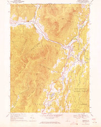
1967 Map of Arlington
USGS Topo · Published 1971About this map
The Batten Kill winds through a valley of varied Vermont settlements in the late 1960s, linking the village of Arlington with the smaller communities of West Arlington and East Arlington. The geography reveals a distinct social fabric defined by valley-floor agriculture and industrial traces, such as the Gravel Pit near the riverbanks. High ridges like Big Spruce Mountain and Grass Mountain dominate the western portion of the sheet, while the eastern side is defined by the Green Mountain National Forest and the residential cluster at Chiselville. Genealogists may find interest in local landmarks like Evergreen Cem or the smaller Cem in the hills, while the mapping of the Fisher Sch and Mt Pleasant Sch preserves the location of rural education centers before further consolidation. The Vermont railroad line runs north-south, following the lower terrain near Lake Shaftsbury and the southern town line.
Find a feature on this map
43 named features on this map. Tap any name to fly to it.
Don’t see what you’re looking for? This feature index may not catch every label — zoom into the map to look around manually.
Map Details
Editions of this 1967 Arlington Map
2 editions found
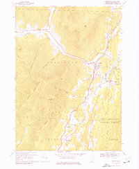
Other maps of this area

1894 · Equinox
USGS Topo · 1:62,500

1895 · Cambridge
USGS Topo · 1:62,500

1896 · Equinox
USGS Topo · 1:62,500

1897 · Hoosick
USGS Topo · 1:62,500

1898 · Cambridge
USGS Topo · 1:62,500

1898 · Bennington
USGS Topo · 1:62,500

1900 · Taconic
USGS Topo · 1:125,000

1900 · Equinox
USGS Topo · 1:62,500

1901 · Cambridge
USGS Topo · 1:62,500

1903 · Mettawee
USGS Topo · 1:125,000