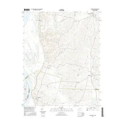
2016 Map of Arlington
USGS Topo · Published 2016About this map
Mississippi River bottomlands and the bluffs of Western Kentucky define this landscape, where the river meets the borders of Carlisle Co and Hickman Co. Along the western edge, a complex network of wetlands and secondary channels includes Straight Slough, Back Slough, and numerous water bodies such as Crooked Lake and Indian Camp Lake. The upland areas are marked by established settlements like Bardwell, Arlington, and Columbus, connected by a grid of rural routes including the Arlington-Berkley Rd. This area is characterized by its numerous small family and community burial grounds, such as Taylor Cem near the river and Dicus Cem further inland. The survey captures the drainage patterns of Truman Cr and Boules Cr as they flow toward the river valley, illustrating the transition from the fertile alluvial plain to the rolling interior hills.
Find a feature on this map
76 named features on this map. Tap any name to fly to it.
Don’t see what you’re looking for? This feature index may not catch every label — zoom into the map to look around manually.
Map Details
Editions of this 2016 Arlington Map
This is the sole edition of this map. No revisions or reprints were ever made.
Other maps of this area

1939 · Wickliffe
USGS Topo · 1:62,500

1939 · Hickman
USGS Topo · 1:62,500

1951 · Blandville
USGS Topo · 1:24,000

1951 · Oakton
USGS Topo · 1:24,000

1951 · Wolf Island
USGS Topo · 1:24,000

1951 · Wickliffe SW
USGS Topo · 1:24,000

1951 · Arlington
USGS Topo · 1:24,000

1951 · Wickliffe
USGS Topo · 1:24,000

1951 · Milburn
USGS Topo · 1:24,000

1952 · Clinton
USGS Topo · 1:24,000