
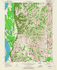
1951 Map of Arlington
USGS Topo · Published 1953About this map
The Mississippi River dominates the western edge of this 1951 landscape, where the alluvial bottoms meet the high bluffs of western Kentucky. Along these heights, Columbus-Belmont State Park preserves a site of significant strategic importance, overlooking the river near Columbus. The map reveals a transition from the marshy lowlands of the river plain, dotted with water bodies like Fish Lake and Goose Pond, to the upland ridges where the agricultural settlements of Arlington and Bardwell are situated.
Find a feature on this map
37 named features on this map. Tap any name to fly to it.
Don’t see what you’re looking for? This feature index may not catch every label — zoom into the map to look around manually.
Map Details
Editions of this 1951 Arlington Map
2 editions found
Other maps of this area

1939 · Wickliffe
USGS Topo · 1:62,500

1939 · Hickman
USGS Topo · 1:62,500

1951 · Blandville
USGS Topo · 1:24,000

1951 · Oakton
USGS Topo · 1:24,000

1951 · Wolf Island
USGS Topo · 1:24,000

1951 · Wickliffe SW
USGS Topo · 1:24,000

1951 · Wickliffe
USGS Topo · 1:24,000

1951 · Milburn
USGS Topo · 1:24,000

1952 · Clinton
USGS Topo · 1:24,000

1952 · Water Valley
USGS Topo · 1:62,500