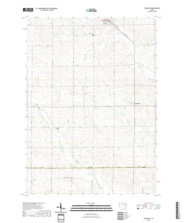
2022 Map of Arlington
USGS Topo · Published 2022About this map
Arlington sits at the northern edge of this agricultural landscape in Fayette County, where the town’s street grid is defined by Main St and High St. The terrain is shaped by the upper reaches of the Maquoketa River and the S Fork Maquoketa River, which carve subtle drainage patterns across the prairie. Small-scale rural history is preserved in the location of Arlington Cem and Union Cem, while the settlement of Maryville provides a secondary point of community interest to the southeast. The map reveals a strictly organized section-line road system, including Co Hwy W51 and Eisenhower Rd, reflecting the long-standing land divisions typical of the region. This 2022 survey captures the persistent rural character of the area, where minor waterways like Brush Cr and Lamont Cr continue to define the local topography amidst extensive farming.
Find a feature on this map
45 named features on this map. Tap any name to fly to it.
Don’t see what you’re looking for? This feature index may not catch every label — zoom into the map to look around manually.
Map Details
Editions of this 2022 Arlington Map
This is the sole edition of this map. No revisions or reprints were ever made.
Other maps of this area

1901 · Oelwein
USGS Topo · 1:125,000

1959 · Dubuque
USGS Topo · 1:250,000

1961 · Dubuque
USGS Topo · 1:250,000

1962 · Dubuque
USGS Topo · 1:250,000

1965 · Wadena
USGS Topo · 1:24,000

1965 · Strawberry Point
USGS Topo · 1:24,000

1965 · Arlington
USGS Topo · 1:24,000
1965 · Volga
USGS Topo · 1:24,000

1965 · Lamont
USGS Topo · 1:24,000

1965 · Dundee
USGS Topo · 1:24,000