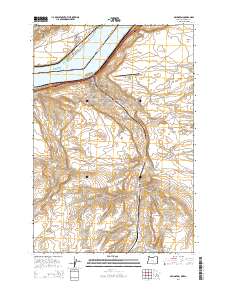
2014 Map of Arlington
USGS Topo · Published 2014About this map
Arlington sits at the confluence of the high desert and the Columbia River, serving as a vital transportation hub along the northern border of Gilliam County. This modern survey illustrates the town's position between the John Day Hwy and the river, where the Lake Umatilla reservoir dominates the northern landscape. Local history and culture are anchored at the Arlington Rodeo Grounds and the Arlington Masonic Cem, while the industrial and logistics character of the region is evidenced by the Arlington Municipal Airport.
Find a feature on this map
36 named features on this map. Tap any name to fly to it.
Don’t see what you’re looking for? This feature index may not catch every label — zoom into the map to look around manually.
Map Details
Editions of this 2014 Arlington Map
This is the sole edition of this map. No revisions or reprints were ever made.
Other maps of this area

1916 · Arlington
USGS Topo · 1:125,000

1953 · The Dalles
USGS Topo · 1:250,000

1956 · The Dalles
USGS Topo · 1:250,000

1957 · The Dalles
USGS Topo · 1:250,000

1962 · Heppner Junction
USGS Topo · 1:24,000

1962 · Wood Gulch
USGS Topo · 1:24,000

1964 · Turner Butte
USGS Topo · 1:24,000

1964 · Shutler Flat
USGS Topo · 1:24,000

1964 · Hickland Butte
USGS Topo · 1:24,000
1964 · Horn Butte
USGS Topo · 1:24,000