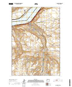
2020 Map of Arlington
USGS Topo · Published 2020About this map
Arlington, Oregon, and Roosevelt, Washington, face each other across the expanse of Lake Umatilla, where the Columbia River marks the state boundary between Gilliam and Klickitat counties. The local geography is defined by deep incisions in the plateau, such as Alkali Canyon and Jones Canyon, which lead down to the riverfront. The town of Arlington is organized around a traditional street grid including Cottonwood ST and Main ST, with the Arlington Masonic Cem situated on the western slopes overlooking the town.
Find a feature on this map
31 named features on this map. Tap any name to fly to it.
Don’t see what you’re looking for? This feature index may not catch every label — zoom into the map to look around manually.
Map Details
Editions of this 2020 Arlington Map
This is the sole edition of this map. No revisions or reprints were ever made.
Other maps of this area

1916 · Arlington
USGS Topo · 1:125,000

1953 · The Dalles
USGS Topo · 1:250,000

1956 · The Dalles
USGS Topo · 1:250,000

1957 · The Dalles
USGS Topo · 1:250,000

1962 · Heppner Junction
USGS Topo · 1:24,000

1962 · Wood Gulch
USGS Topo · 1:24,000

1964 · Turner Butte
USGS Topo · 1:24,000

1964 · Shutler Flat
USGS Topo · 1:24,000

1964 · Hickland Butte
USGS Topo · 1:24,000
1964 · Horn Butte
USGS Topo · 1:24,000