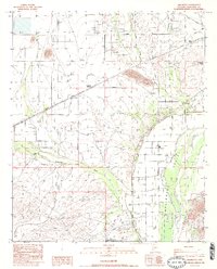
1984 Map of Arlington
USGS Topo · Published 1984About this map
Arlington and the surrounding Arlington Valley serve as a hub of agricultural and industrial activity along the northern banks of the Gila River in the mid-1980s. The landscape is defined by the critical management of water through the Arlington Canal and the natural drainage of Centennial Wash. Infrastructure such as the Southern Pacific railroad and the Arlington Substation supports the local economy, while the Hassayampa Cotton Gin points to the area's agricultural focus.
Find a feature on this map
23 named features on this map. Tap any name to fly to it.
Don’t see what you’re looking for? This feature index may not catch every label — zoom into the map to look around manually.
Map Details
Editions of this 1984 Arlington Map
2 editions found
Other maps of this area

1951 · Cotton Center
USGS Topo · 1:62,500

1951 · Woolsey Peak
USGS Topo · 1:62,500

1954 · Phoenix
USGS Topo · 1:250,000

1957 · Phoenix
USGS Topo · 1:250,000

1958 · Phoenix
USGS Topo · 1:250,000

1958 · Buckeye NW
USGS Topo · 1:24,000

1958 · Hassayampa
USGS Topo · 1:24,000

1958 · Buckeye
USGS Topo · 1:62,500

1960 · Phoenix
USGS Topo · 1:250,000

1962 · Arlington
USGS Topo · 1:62,500