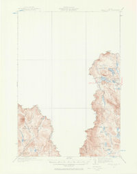
1932 Map of Arnold Pond
USGS Topo · Published 1966About this map
Coburn Gore and the surrounding unorganized territories of northern Franklin County are defined by a network of remote waterways and high peaks along the international boundary. This 1932 survey, which utilized aerial photography from the Army Air Corps, captures the border landscape where the U.S. Customs station marks the passage between Maine and Quebec. The terrain is divided into historic land grants and townships such as Massachusetts Gore and Seven Ponds T3 R5, characterized by significant water bodies like Arnold Pond and Big Island Pond.
Find a feature on this map
41 named features on this map. Tap any name to fly to it.
Don’t see what you’re looking for? This feature index may not catch every label — zoom into the map to look around manually.
Map Details
Editions of this 1932 Arnold Pond Map
3 editions found
Other maps of this area

1927 · Moose Bog
USGS Topo · 1:48,000

1927 · Second Lake
USGS Topo · 1:62,500

1928 · Chain Lakes
USGS Topo · 1:48,000

1928 · Skinner
USGS Topo · 1:48,000

1931 · Cupsuptic
USGS Topo · 1:48,000

1931 · Skinner
USGS Topo · 1:62,500

1931 · Moose Bog
USGS Topo · 1:62,500

1932 · Kennebago Lake
USGS Topo · 1:48,000

1932 · Second Lake
USGS Topo · 1:62,500

1932 · Arnold Pond
USGS Topo · 1:48,000