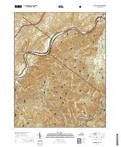
2019 Map of Arnold Valley
USGS Topo · Published 2019About this map
Jefferson National Forest dominates the landscape of this region, where the James River cuts through the ridges of the Blue Ridge. The area is defined by a deep intersection of natural landmarks and historic transport corridors, from the CSX Transportation rail line serving Natural Bridge Station and Greenlee to the winding Blue Ridge Parkway along the southern heights. Higher elevations like Apple Orchard Mtn and Thunder Hill overlook a network of hollows and gaps, including Gilmore Hollow and Hoop Pole Gap. Local history is preserved in several rural burial grounds such as Mount Olivet Cem, Bryant Cem, and Watson Cem. The Appalachian National Scenic Trail traverses the central ridges, crossing over Floyd Mtn and Bryant Ridge, illustrating the long-standing recreational significance of this wilderness area alongside the old industrial river settlements at Gilmore Mills and Rocky Point.
Find a feature on this map
77 named features on this map. Tap any name to fly to it.
Don’t see what you’re looking for? This feature index may not catch every label — zoom into the map to look around manually.
Map Details
Editions of this 2019 Arnold Valley Map
This is the sole edition of this map. No revisions or reprints were ever made.
Other maps of this area

1890 · Roanoke
USGS Topo · 1:125,000

1891 · Roanoke
USGS Topo · 1:125,000

1892 · Lynchburg
USGS Topo · 1:125,000

1894 · Natural Bridge
USGS Topo · 1:125,000

1894 · Lexington
USGS Topo · 1:125,000

1894 · Natural Bridge
USGS Topo · 1:62,500

1907 · Natural Bridge Special
USGS Topo · 1:62,500

1935 · Buena Vista
USGS Topo · 1:48,000

1939 · Buena Vista
USGS Topo · 1:62,500

1940 · Buena Vista
USGS Topo · 1:62,500