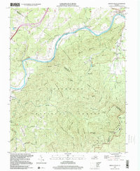
1999 Map of Arnold Valley
USGS Topo · Published 2000About this map
The James River carves a deep path through this section of the Blue Ridge, where the Chesapeake and Ohio railroad follows the northern bank. This late-twentieth-century landscape is defined by the transition from the river bottom settlements like Natural Bridge Station and Gilmore Mills to the steep elevations of Jefferson National Forest. Industrial history is visible at the Glenwood Furnace near the East Fork of Hopper Creek, evidence of the region's earlier iron production.
Find a feature on this map
75 named features on this map. Tap any name to fly to it.
Don’t see what you’re looking for? This feature index may not catch every label — zoom into the map to look around manually.
Map Details
Editions of this 1999 Arnold Valley Map
This is the sole edition of this map. No revisions or reprints were ever made.
Other maps of this area

1890 · Roanoke
USGS Topo · 1:125,000

1891 · Roanoke
USGS Topo · 1:125,000

1892 · Lynchburg
USGS Topo · 1:125,000

1894 · Natural Bridge
USGS Topo · 1:125,000

1894 · Lexington
USGS Topo · 1:125,000

1894 · Natural Bridge
USGS Topo · 1:62,500

1907 · Natural Bridge Special
USGS Topo · 1:62,500

1935 · Buena Vista
USGS Topo · 1:48,000

1939 · Buena Vista
USGS Topo · 1:62,500

1940 · Buena Vista
USGS Topo · 1:62,500