
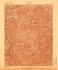
1907 Map of Arnoldsburg
USGS Topo · Published 1907About this map
Grantsville serves as the focal point of this 1907 survey, situated along a sharp bend of the Little Kanawha River. The landscape is defined by the dense dendritic drainage of the central West Virginia hills, where settlements like Brooksville Big Bend PO and Annamoriah follow the narrow river valleys and high ridges. The map captures a moment when rural life centered around local hubs such as Mt Vernon Church and Victory Church.
Find a feature on this map
136 named features on this map. Tap any name to fly to it.
Don’t see what you’re looking for? This feature index may not catch every label — zoom into the map to look around manually.
Map Details
Editions of this 1907 Arnoldsburg Map
2 editions found
Other maps of this area

1893 · Sutton
USGS Topo · 1:125,000

1906 · Holbrook
USGS Topo · 1:62,500

1906 · Glenville
USGS Topo · 1:62,500

1906 · Elizabeth
USGS Topo · 1:62,500

1906 · Otter
USGS Topo · 1:62,500

1906 · Walton
USGS Topo · 1:62,500

1907 · Otter
USGS Topo · 1:62,500

1907 · Harrisville
USGS Topo · 1:62,500

1907 · Spencer
USGS Topo · 1:62,500

1907 · Walton
USGS Topo · 1:62,500