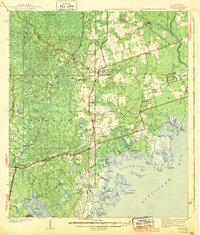
1943 Map of Arran
USGS Topo · Published 1943About this map
The county seat of Crawfordville serves as the central hub for Wakulla County in the late 1930s, surrounded by a landscape defined by the Apalachicola National Forest and the coastal marshes of the St Marks Wildlife Refuge. The Seaboard Air Line RR cuts through the western timberlands, connecting small communities like Arran and Ashmore to the wider region. Along the coast, the map documents the intricate geography of Oyster Bay and Dickerson Bay, where fishing and maritime life centered around Panacea and Stokley Landing. This survey preserves the locations of several rural institutions, including the Mt Pleasant Sch and Pilgrims Rest Ch, alongside numerous family burial grounds such as Roddenberry Cem and Oak Park Cem. The presence of Lawhorns Mill and Bottoms Fishery illustrates the local reliance on timber and the Gulf's waters during this era.
Find a feature on this map
86 named features on this map. Tap any name to fly to it.
Don’t see what you’re looking for? This feature index may not catch every label — zoom into the map to look around manually.
Map Details
Editions of this 1943 Arran Map
2 editions found
Other maps of this area

1940 · Tallahassee
USGS Topo · 1:62,500

1940 · Arran
USGS Topo · 1:62,500

1942 · Tallahassee
USGS Topo · 1:62,500

1943 · Arran
USGS Topo · 1:62,500

1943 · Tallahassee
USGS Topo · 1:62,500

1943 · Lake Talquin
USGS Topo · 1:62,500

1943 · St. Teresa Beach
USGS Topo · 1:24,000

1943 · Lighthouse Point
USGS Topo · 1:24,000

1945 · Bradwell Bay
USGS Topo · 1:31,680

1945 · Lighthouse Point
USGS Topo · 1:31,680