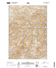
2020 Map of Arrastra Butte
USGS Topo · Published 2020About this map
Arrastra Butte and Coyote Mtn anchor this high-elevation terrain along the border of Wasco and Jefferson Counties. This landscape is defined by a series of deep drainage systems, including Vanderhoof Canyon, Fir Tree Canyon, and Gallagher Canyon, which reveal the complex erosion patterns of the region. The map tracks the passage of Currant Cr and Little Muddy Cr through the southern reaches, while the northern section is marked by seasonal flows like Dry Cr. Sparse road development, including Big Muddy Rd and NE Gosner Rd, suggests a remote ranching or resource-management character. High points such as Lyons Ridge, Robinson Ridge, and the distinctive Black Rock provide significant topographical landmarks for navigation and land use study in this part of Oregon.
Find a feature on this map
23 named features on this map. Tap any name to fly to it.
Don’t see what you’re looking for? This feature index may not catch every label — zoom into the map to look around manually.
Map Details
Editions of this 2020 Arrastra Butte Map
This is the sole edition of this map. No revisions or reprints were ever made.
Other maps of this area

1926 · Mitchell
USGS Topo · 1:125,000

1955 · Bend
USGS Topo · 1:250,000

1957 · Bend
USGS Topo · 1:250,000

1958 · Bend
USGS Topo · 1:250,000

1966 · Antelope
USGS Topo · 1:62,500

1966 · Clarno
USGS Topo · 1:62,500

1968 · Horse Heaven Creek
USGS Topo · 1:24,000

1968 · Axehandle Butte
USGS Topo · 1:24,000
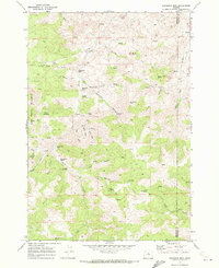
1968 · Sandrock Mtn
USGS Topo · 1:24,000

1981 · Stephenson Mountain
USGS Topo · 1:100,000