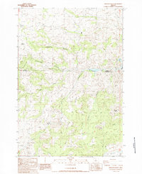
1987 Map of Arrastra Butte
USGS Topo · Published 1988About this map
Queen Oregon Mines sit at the southern end of a dissected upland where the Wasco and Jefferson county lines meet. The terrain is defined by a series of steep drainages, including Gallagher Canyon, Vanderhoof Canyon, and Fir Tree Canyon, which carve through the high ridges. These landforms indicate a landscape shaped by intermittent water flow, evidenced by the presence of Dry Creek and Currant Creek.
Find a feature on this map
18 named features on this map. Tap any name to fly to it.
Don’t see what you’re looking for? This feature index may not catch every label — zoom into the map to look around manually.
Map Details
Editions of this 1987 Arrastra Butte Map
This is the sole edition of this map. No revisions or reprints were ever made.
Other maps of this area

1926 · Mitchell
USGS Topo · 1:125,000

1955 · Bend
USGS Topo · 1:250,000

1957 · Bend
USGS Topo · 1:250,000

1958 · Bend
USGS Topo · 1:250,000

1966 · Antelope
USGS Topo · 1:62,500

1966 · Clarno
USGS Topo · 1:62,500

1968 · Horse Heaven Creek
USGS Topo · 1:24,000

1968 · Axehandle Butte
USGS Topo · 1:24,000
1968 · Sandrock Mtn
USGS Topo · 1:24,000

1981 · Stephenson Mountain
USGS Topo · 1:100,000