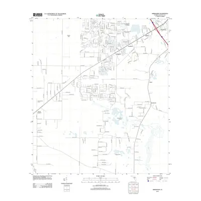
2012 Map of Arredondo
USGS Topo · Published 2012About this map
Arredondo and Kanapaha anchor this region of Alachua County, where the sprawling suburban growth of southwest Gainesville meets the distinctive karst topography of Florida's interior. The landscape is defined by vast natural depressions and wetlands, including Lake Kanapaha, the expansive Kanapaha Prairie, and Hickory Sink to the northwest. This 2012 survey captures a transition in land use, showing established residential neighborhoods like Riceland and Robinswood alongside significant industrial and civic infrastructure such as the Kanapaha Wastewater Treatment Facility and the Gainesville Speedway. The historic Kanapaha Presbyterian Church Cem remains a central landmark for local genealogy. To the south and west, the map transitions toward more agricultural and open lands near Peach Orchard and the northern edge of Levy Lake, illustrating the area's ongoing shift from rural homesteads to a more developed landscape.
Find a feature on this map
113 named features on this map. Tap any name to fly to it.
Don’t see what you’re looking for? This feature index may not catch every label — zoom into the map to look around manually.
Map Details
Editions of this 2012 Arredondo Map
This is the sole edition of this map. No revisions or reprints were ever made.
Other maps of this area

1890 · Arredondo
USGS Topo · 1:62,500

1892 · Arredondo
USGS Topo · 1:62,500

1894 · Arredondo
USGS Topo · 1:62,500

1895 · Williston
USGS Topo · 1:62,500

1954 · Gainesville
USGS Topo · 1:250,000

1955 · Bronson NE
USGS Topo · 1:24,000

1958 · Gainesville
USGS Topo · 1:250,000

1959 · Gainesville
USGS Topo · 1:250,000
1966 · Micanopy
USGS Topo · 1:24,000

1966 · Gainesville West
USGS Topo · 1:24,000