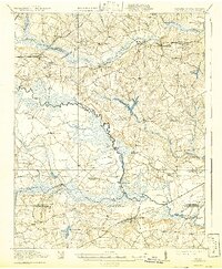
1920 Map of Arringdale
USGS Topo · Published 1942About this map
Meherrin River winds through this coastal plain landscape, serving as a natural boundary between Southampton and Greensville Counties in Virginia, and eventually reaching down toward the Virginia North Carolina border. The geography is defined by a dense network of swampy lowlands including Meherrin Swamp, Cypress Swamp, and Buckhorn Swamp, which shaped the early agricultural and transport patterns of the region. Rail transport is central to the area's development, with the Southern railroad and the Seaboard Air Line cutting through the terrain to serve hubs like Arringdale and Drewryville. Small rural communities are anchored by numerous institutions, such as Rising Star School and Mt Zion Church, while industry is represented by features like Taylors Millpond and Jordans Mill. The map also preserves traces of older infrastructure, specifically an Old Railroad Grade south of the river.
Find a feature on this map
65 named features on this map. Tap any name to fly to it.
Don’t see what you’re looking for? This feature index may not catch every label — zoom into the map to look around manually.
Map Details
Editions of this 1920 Arringdale Map
3 editions found
Other maps of this area

1919 · Jarratt
USGS Topo · 1:62,500

1919 · Mc Kenney
USGS Topo · 1:48,000

1919 · Homeville
USGS Topo · 1:48,000

1919 · Boykins
USGS Topo · 1:48,000

1919 · Emporia
USGS Topo · 1:62,500

1919 · Arringdale
USGS Topo · 1:48,000

1920 · Homeville
USGS Topo · 1:62,500

1920 · Boykins
USGS Topo · 1:62,500

1920 · Arringdale
USGS Topo · 1:62,500

1921 · Mc Kenney
USGS Topo · 1:62,500