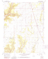
1965 Map of Arriola
USGS Topo · Published 1988About this map
Hovenweep National Monument Goodman Point Group preserves a high-desert landscape marked by ancient history and modern ranching. This mid-1960s survey documents a unique overlap of civilizations, where archaeological sites like the Indian Ruins near Goodman Point sit adjacent to working agricultural infrastructure. The settlement of Arriola serves as a local hub, connected to the northern hamlet of Lewis by a network of rural roads such as Arriola Road. The rugged western terrain is dominated by Yellow Jacket Canyon and Dawson Draw, while the eastern portion reveals the intricate water management systems of the day, including the Lone Pine Lateral and the Narraguinnep Reservoir. For genealogists, the map identifies specific burial sites including Arriola Cem and Goodman Point Cem, offering precise locations for family history research in Montezuma County.
Find a feature on this map
27 named features on this map. Tap any name to fly to it.
Don’t see what you’re looking for? This feature index may not catch every label — zoom into the map to look around manually.
Map Details
Editions of this 1965 Arriola Map
3 editions found
Other maps of this area

1956 · Cortez
USGS Topo · 1:250,000

1957 · Moqui SE
USGS Topo · 1:24,000

1958 · Cortez SW
USGS Topo · 1:24,000

1958 · Cortez
USGS Topo · 1:250,000

1959 · Cortez
USGS Topo · 1:250,000

1962 · Cortez
USGS Topo · 1:250,000

1965 · Woods Canyon
USGS Topo · 1:24,000

1965 · Cortez
USGS Topo · 1:24,000

1965 · Dolores West
USGS Topo · 1:24,000

1965 · Yellow Jacket
USGS Topo · 1:24,000