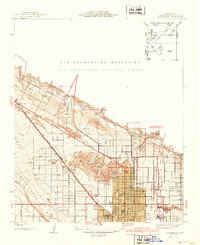
1941 Map of Arrowhead
USGS Topo · Published 1941About this map
The City of San Bernardino expands northward toward the San Bernardino Mountains in this pre-war survey, showcasing a landscape defined by the transition from urban grid to alluvial wash. Significant aviation history is recorded at the Shandin Hills Airport, situated near the base of the Shandin Hills and its Little Mtn Lookout. The intricate rail infrastructure of the Atchison Topeka and Santa Fe Railway and the Union Pacific lines dominates the western portion of the sheet, converging near settlements like Ono and Verdemont. The map reveals the early residential development of Muscoy and Arrowhead, while rural outposts such as Copia Ranch and the Del Rosa Ranger Sta mark the edge of the San Bernardino National Forest. This record captures the region's essential water management and transportation corridors, including the winding Rim of the World Drive as it begins its ascent into the mountains.
Find a feature on this map
36 named features on this map. Tap any name to fly to it.
Don’t see what you’re looking for? This feature index may not catch every label — zoom into the map to look around manually.
Map Details
Editions of this 1941 Arrowhead Map
2 editions found
Other maps of this area

1896 · San Bernardino
USGS Topo · 1:62,500

1898 · San Bernardino
USGS Topo · 1:62,500

1899 · Redlands
USGS Topo · 1:62,500

1901 · Southern California Sheet No. 1
USGS Topo · 1:250,000

1901 · San Bernardino
USGS Topo · 1:62,500

1901 · Redlands
USGS Topo · 1:62,500

1902 · Deep Creek
USGS Topo · 1:62,500

1902 · Hesperia
USGS Topo · 1:62,500

1904 · Southern California Sheet No. 1
USGS Topo · 1:250,000

1936 · Devore
USGS Topo · 1:31,680