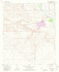
1958 Map of Arroyo Cuervo
USGS Topo · Published 1981About this map
The Rincon Valley landscape in southern New Mexico is defined by the vital waters of the Rio Grande and the intricate network of the Garfield Canal and irrigation laterals. This arid terrain is deeply scarred by numerous dry washes, including Arroyo Cuervo, Arroyo Yeso, and McLeod Arroyo, which illustrate the region's flash-flood hydrology. Cultural landmarks are scattered throughout the brush, notably La Capilla de Don Silverio and various Ruins that point to earlier habitation and small-scale religious centers in the desert. Commercial and industrial activity is represented by a Claypit and the Hatch Airport (Aband), reflecting shifts in local transportation and land use. Genealogists may find interest in the small Cem located near the eastern edge of the survey, a quiet marker of the families who settled this rugged border between Sierra and Dona Ana Counties.
Find a feature on this map
21 named features on this map. Tap any name to fly to it.
Don’t see what you’re looking for? This feature index may not catch every label — zoom into the map to look around manually.
Map Details
Editions of this 1958 Arroyo Cuervo Map
2 editions found
Other maps of this area

1955 · Las Cruces
USGS Topo · 1:250,000

1958 · Las Cruces
USGS Topo · 1:250,000

1958 · Arroyo Cuervo
USGS Topo · 1:24,000

1959 · Hatch
USGS Topo · 1:24,000
1959 · Souse Springs
USGS Topo · 1:24,000

1959 · Upham
USGS Topo · 1:62,500

1961 · Nutt
USGS Topo · 1:62,500

1961 · Clark Spring Canyon
USGS Topo · 1:24,000

1961 · Garfield
USGS Topo · 1:24,000

1982 · Hatch
USGS Topo · 1:100,000