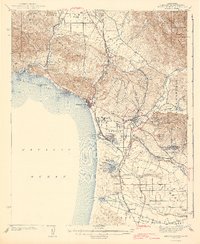
1942 Map of Arroyo Grande
USGS Topo · Published 1942About this map
Arroyo Grande serves as the inland anchor for this coastal survey, where the fertile Arroyo Grande Valley meets the dunes and wetlands of the Cienega Valley. Near the coast, the rail infrastructure of the Southern Pacific RR and the Pacific Coast RR—including a narrow-gage line—dictated the growth of shipping and travel between Mallagh Landing and Oceano Beach. The landscape is dotted with early 20th-century social and industrial markers, from the resort atmosphere of Ontario Hot Springs and Sycamore Springs to the essential rural infrastructure of Independence Sch and Canyon Sch. Inland, the San Luis Range and Santa Lucia Range hem in the coastal shelf, creating a distinct corridor for transport and settlement. Notable smaller water bodies like Hospital Lake and Bolsa Chico Lake populate the lowlands behind Pismo Beach, showing the original drainage patterns before modern development altered the hydrology of the Central Coast.
Find a feature on this map
79 named features on this map. Tap any name to fly to it.
Don’t see what you’re looking for? This feature index may not catch every label — zoom into the map to look around manually.
Map Details
Editions of this 1942 Arroyo Grande Map
3 editions found

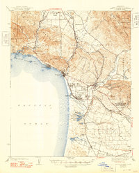
Other maps of this area

1897 · Port Harford
USGS Topo · 1:62,500

1897 · San Luis Obispo
USGS Topo · 1:62,500

1897 · Cayucos
USGS Topo · 1:62,500

1897 · Arroyo Grande
USGS Topo · 1:62,500

1900 · San Luis
USGS Topo · 1:125,000

1905 · Guadalupe
USGS Topo · 1:125,000

1905 · Lompoc
USGS Topo · 1:125,000

1922 · Pozo
USGS Topo · 1:62,500

1922 · Nipomo
USGS Topo · 1:62,500

1937 · Cayucos
USGS Topo · 1:62,500