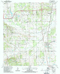
1987 Map of Artesia
USGS Topo · Published 1987About this map
Artesia serves as a central rail junction on this mid-1980s survey, where the G & M and C & G lines converge near the Oktibbeha and Lowndes County line. The landscape is defined by the drainages of Sand Creek, Catalpa Creek, and Red Bud Creek, which supported a network of rural settlements and family-named landmarks. Genealogists will find a wealth of burial sites including Fox Cem, Rice Cem, and Seitz Cem, alongside numerous country sanctuaries such as True Vine Ch, Austin Ch, and Belaire Ch. The map also captures the modern transition of the area, featuring the Oktibbeha Airport, the Golden Triangle Voc-Tech Sch, and a Drive-in Theater located near the western edge. Traces of the region's transport history are visible along the Old Railroad Grade, which cuts through the community of Sessums.
Find a feature on this map
38 named features on this map. Tap any name to fly to it.
Don’t see what you’re looking for? This feature index may not catch every label — zoom into the map to look around manually.
Map Details
Editions of this 1987 Artesia Map
This is the sole edition of this map. No revisions or reprints were ever made.
Other maps of this area

1953 · West Point
USGS Topo · 1:250,000

1958 · West Point
USGS Topo · 1:250,000

1959 · Artesia
USGS Topo · 1:62,500

1959 · West Point
USGS Topo · 1:62,500

1959 · Pheba
USGS Topo · 1:62,500

1963 · West Point
USGS Topo · 1:250,000

1965 · Starkville
USGS Topo · 1:24,000

1965 · Bluff Lake
USGS Topo · 1:24,000

1982 · West Point
USGS Topo · 1:100,000

1984 · West Point
USGS Topo · 1:250,000