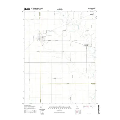
2015 Map of Arthur
USGS Topo · Published 2015About this map
Arthur serves as the central hub on this Illinois prairie landscape, where the street grid of W Progress St and E Illinois St meets the agricultural hinterland. The map documents a critical drainage network shaped by the Kaskaskia River and the W Fork Kaskaskia River, which meander through the eastern portion of the quadrangle. This area is defined by the intersection of three counties—Moultrie, Douglas, and Coles—creating a unique point of study for researchers interested in regional jurisdiction and land use. Genealogists will find significant value in the placement of small, rural burial grounds like Yoder Cem, Fillmore Cem, and Miller Cem, which are scattered among the farmsteads. The presence of settlements like Bourbon to the north and Chesterville to the east highlights the dispersed community structure typical of this fertile region, connected by a dense network of range and township roads.
Find a feature on this map
59 named features on this map. Tap any name to fly to it.
Don’t see what you’re looking for? This feature index may not catch every label — zoom into the map to look around manually.
Map Details
Editions of this 2015 Arthur Map
This is the sole edition of this map. No revisions or reprints were ever made.
Other maps of this area

1935 · Arcola
USGS Topo · 1:48,000

1935 · Sullivan
USGS Topo · 1:48,000

1940 · Sullivan
USGS Topo · 1:62,500

1940 · Arcola
USGS Topo · 1:62,500

1950 · Tuscola
USGS Topo · 1:62,500

1955 · Bement
USGS Topo · 1:62,500

1958 · Decatur
USGS Topo · 1:250,000

1961 · Decatur
USGS Topo · 1:250,000
1975 · Tuscola SW
USGS Topo · 1:24,000
1975 · Tuscola SE
USGS Topo · 1:24,000