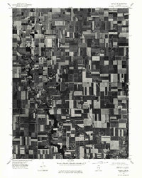
1975 Map of Tuscola SW
USGS Topo · Published 1977About this map
Atwood and Garrett sit at the heart of this mid-1970s orthophotoquad, which captures the rhythmic geometry of Illinois farmland during the harvest season. Unlike traditional line-drawn maps, this aerial imagery provides a direct look at the rectilinear road grids and agricultural plots that dominate the Douglas County landscape. The winding course of the Kaskaskia River cuts through the southwest, its dark, forested corridor providing a sharp natural contrast to the surrounding industrial-scale fields. This specific aerial perspective, taken on October 3, 1975, reveals the precise density of the small-town street plans and the proximity of individual farmsteads to the regional transportation network, documenting the region's rural character before further late-century modernization.
Find a feature on this map
3 named features on this map. Tap any name to fly to it.
Don’t see what you’re looking for? This feature index may not catch every label — zoom into the map to look around manually.
Map Details
Editions of this 1975 Tuscola SW Map
This is the sole edition of this map. No revisions or reprints were ever made.
Other maps of this area

1935 · Arcola
USGS Topo · 1:48,000

1935 · Sullivan
USGS Topo · 1:48,000

1940 · Sullivan
USGS Topo · 1:62,500

1940 · Arcola
USGS Topo · 1:62,500

1950 · Tuscola
USGS Topo · 1:62,500

1955 · Bement
USGS Topo · 1:62,500

1958 · Decatur
USGS Topo · 1:250,000

1961 · Decatur
USGS Topo · 1:250,000
1975 · Tuscola NE
USGS Topo · 1:24,000
1975 · Tuscola NW
USGS Topo · 1:24,000