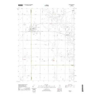
2018 Map of Arthur
USGS Topo · Published 2018About this map
Arthur serves as the primary hub of this East Central Illinois landscape, where the tri-county corner of Moultrie, Douglas, and Coles counties meets. The village street grid is densely developed, extending south of Industrial Park along the North-South Co Hwy 12 corridor. This region is defined by its methodical agricultural layout and the intricate drainage of the upper Kaskaskia watershed. The W Fork Kaskaskia River and Lake Fork wind through the flatlands, eventually joining the main channel of the Kaskaskia River near the eastern edge of the quadrangle. Small rural centers like Chesterville and Bourbon remain focal points for local transport. Genealogists will find several burial sites preserved among the fields, including Yoder Cem, Miller Cem, and Fillmore Cem, which mark the presence of early family settlements and faith communities in this fertile prairie district.
Find a feature on this map
86 named features on this map. Tap any name to fly to it.
Don’t see what you’re looking for? This feature index may not catch every label — zoom into the map to look around manually.
Map Details
Editions of this 2018 Arthur Map
This is the sole edition of this map. No revisions or reprints were ever made.
Other maps of this area

1935 · Arcola
USGS Topo · 1:48,000

1935 · Sullivan
USGS Topo · 1:48,000

1940 · Sullivan
USGS Topo · 1:62,500

1940 · Arcola
USGS Topo · 1:62,500

1950 · Tuscola
USGS Topo · 1:62,500

1955 · Bement
USGS Topo · 1:62,500

1958 · Decatur
USGS Topo · 1:250,000

1961 · Decatur
USGS Topo · 1:250,000
1975 · Tuscola SW
USGS Topo · 1:24,000
1975 · Tuscola SE
USGS Topo · 1:24,000