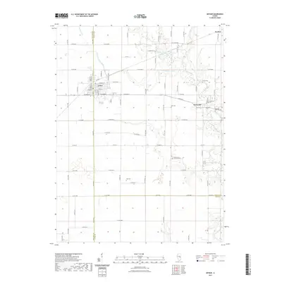
2021 Map of Arthur
USGS Topo · Published 2021About this map
Arthur serves as the primary hub of this Illinois prairie landscape, where the grid of rural township roads meets a growing commercial center featuring an Industrial Park. The area is defined by the headwaters and branches of the Kaskaskia River, including the W Fork Kaskaskia River and its tributary Bolin Br. These waterways cut through a productive agricultural layout, with the small settlements of Chesterville and Bourbon marking historical crossroads nearby.
Find a feature on this map
84 named features on this map. Tap any name to fly to it.
Don’t see what you’re looking for? This feature index may not catch every label — zoom into the map to look around manually.
Map Details
Editions of this 2021 Arthur Map
This is the sole edition of this map. No revisions or reprints were ever made.
Other maps of this area

1935 · Arcola
USGS Topo · 1:48,000

1935 · Sullivan
USGS Topo · 1:48,000

1940 · Sullivan
USGS Topo · 1:62,500

1940 · Arcola
USGS Topo · 1:62,500

1950 · Tuscola
USGS Topo · 1:62,500

1955 · Bement
USGS Topo · 1:62,500

1958 · Decatur
USGS Topo · 1:250,000

1961 · Decatur
USGS Topo · 1:250,000
1975 · Tuscola SW
USGS Topo · 1:24,000
1975 · Tuscola SE
USGS Topo · 1:24,000