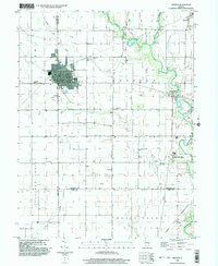
1998 Map of Arthur
USGS Topo · Published 2003About this map
The village of Arthur serves as the central hub of this Central Illinois landscape, situated at the junction of Moultrie and Douglas counties. The area is characterized by a high concentration of parochial educational and religious sites, such as the Mennonite School and German School, which reflect the region's cultural heritage. To the east, the Kaskaskia River and Lake Fork wind through the prairie, supporting the settlement of Chesterville.
Find a feature on this map
39 named features on this map. Tap any name to fly to it.
Don’t see what you’re looking for? This feature index may not catch every label — zoom into the map to look around manually.
Map Details
Editions of this 1998 Arthur Map
This is the sole edition of this map. No revisions or reprints were ever made.
Other maps of this area

1935 · Arcola
USGS Topo · 1:48,000

1935 · Sullivan
USGS Topo · 1:48,000

1940 · Sullivan
USGS Topo · 1:62,500

1940 · Arcola
USGS Topo · 1:62,500

1950 · Tuscola
USGS Topo · 1:62,500

1955 · Bement
USGS Topo · 1:62,500

1958 · Decatur
USGS Topo · 1:250,000

1961 · Decatur
USGS Topo · 1:250,000
1975 · Tuscola SW
USGS Topo · 1:24,000
1975 · Tuscola SE
USGS Topo · 1:24,000