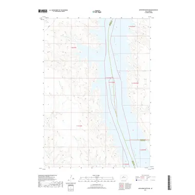
2017 Map of Artichoke Butte NW
USGS Topo · Published 2017About this map
The Missouri River corridor dominates this landscape, where the waters of Lake Oahe fill the valley along the borders of Dewey, Potter, and Sully Counties. This modern survey reflects the vast reservoir system that altered the central South Dakota riverbanks, submerged historical shorelines, and created the intricate inlets visible at Pascal Cr and Parker Cr. To the west of the water, the terrain is marked by the drainages of Bull Cr and Alberts Cr, which cut through the high plains of the Cheyenne River Reservation. Transportation is sparse in this open country, primarily represented by Bia Rd 8 winding through the northwest corner. The map provides a clear view of the Public Land Survey System grid, including T12N R30E and T117N R79W, documenting the administrative boundaries and township lines that define land ownership in this riverine region.
Find a feature on this map
17 named features on this map. Tap any name to fly to it.
Don’t see what you’re looking for? This feature index may not catch every label — zoom into the map to look around manually.
Map Details
Editions of this 2017 Artichoke Butte NW Map
This is the sole edition of this map. No revisions or reprints were ever made.
Other maps of this area

1953 · McIntosh
USGS Topo · 1:250,000

1954 · Pierre
USGS Topo · 1:250,000

1958 · Pierre
USGS Topo · 1:250,000

1958 · McIntosh
USGS Topo · 1:250,000

1965 · Artichoke Butte
USGS Topo · 1:24,000

1965 · Artichoke Butte SW
USGS Topo · 1:24,000

1969 · No Heart Creek SE
USGS Topo · 1:24,000

1969 · Artichoke Butte NW
USGS Topo · 1:24,000

1969 · Patch Skin Buttes SW
USGS Topo · 1:24,000

1969 · Patch Skin Buttes SE
USGS Topo · 1:24,000