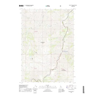
2020 Map of Artillery Dome
USGS Topo · Published 2020About this map
The Middle Fork Salmon River carves a deep corridor through the heart of the Boise National Forest and Challis National Forest, defining the wild boundary between Valley and Custer counties. This section of the river, designated as the Middle Fork Salmon Wild and Scenic River, is characterized by high-energy water features including the Pistol Creek Rapids and Powerhouse Rapids. The landscape is dominated by heavy vertical relief, anchored by the high prominence of Artillery Dome and the sprawling Big Baldy Ridge. Geothermal activity is present at the Sheeheater Hot Springs near the river's edge, while various drainage systems such as Little Pistol Creek and Rapid River feed into the main canyon. The map reveals a wilderness area largely devoid of modern development, where topographic landmarks like Pistol Creek Ridge and Artillery Lake serve as primary navigational points.
Find a feature on this map
44 named features on this map. Tap any name to fly to it.
Don’t see what you’re looking for? This feature index may not catch every label — zoom into the map to look around manually.
Map Details
Editions of this 2020 Artillery Dome Map
This is the sole edition of this map. No revisions or reprints were ever made.
Other maps of this area

1937 · Yellow Pine
USGS Topo · 1:48,000

1943 · Yellow Pine
USGS Topo · 1:62,500

1957 · Challis
USGS Topo · 1:250,000

1960 · Challis
USGS Topo · 1:250,000

1961 · Greyhound Ridge
USGS Topo · 1:62,500

1961 · Chinook Mtn
USGS Topo · 1:62,500

1963 · Challis
USGS Topo · 1:250,000
1973 · Big Chief Creek
USGS Topo · 1:24,000
1973 · Big Baldy
USGS Topo · 1:24,000
1973 · Pungo Mountain
USGS Topo · 1:24,000