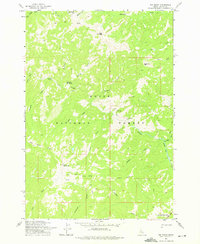
1973 Map of Big Baldy
USGS Topo · Published 1975About this map
Kwiskwis Hot Spring sits at the center of this 1970s wilderness survey, where the Boise National Forest meets the Payette National Forest. This high-altitude landscape is defined by the prominent Big Baldy Ridge, which culminates at the Lookout Big Baldy station. The drainage pattern is complex, with Indian Creek and its many tributaries, such as Wick iup Creek and Endoah Creek, carving deep paths through the terrain. The presence of the Indian Trail and various stretches of Pack Trail indicates the traditional routes used to traverse these remote peaks before modern development. These paths follow the natural contours between landmarks like Battleaxe Mtn and Red Peak, reflecting a landscape preserved for its natural resources and primitive navigation.
Find a feature on this map
31 named features on this map. Tap any name to fly to it.
Don’t see what you’re looking for? This feature index may not catch every label — zoom into the map to look around manually.
Map Details
Editions of this 1973 Big Baldy Map
This is the sole edition of this map. No revisions or reprints were ever made.
Other maps of this area

1937 · Yellow Pine
USGS Topo · 1:48,000

1943 · Yellow Pine
USGS Topo · 1:62,500

1957 · Challis
USGS Topo · 1:250,000

1960 · Challis
USGS Topo · 1:250,000

1961 · Greyhound Ridge
USGS Topo · 1:62,500

1961 · Chinook Mtn
USGS Topo · 1:62,500

1963 · Challis
USGS Topo · 1:250,000
1973 · Rainbow Peak
USGS Topo · 1:24,000
1973 · Big Chief Creek
USGS Topo · 1:24,000
1973 · Safety Creek
USGS Topo · 1:24,000