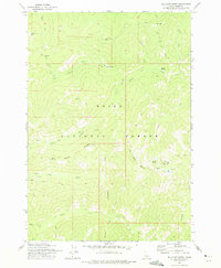
1973 Map of Big Chief Creek
USGS Topo · Published 1975About this map
The Boise National Forest in central Idaho was a hub of remote backcountry activity during the early 1970s, as documented in this survey of the Salmon River Mountains. The landscape is defined by the headwaters of Big Chief Creek and Pistol Creek, where high-altitude ridges like Big Baldy Ridge and Papoose Ridge separate the steep drainage basins. Evidence of the region’s extractive history is visible at the Springfield Mine, where identified Tailings sit near Springfield Creek, alongside several unnamed Prospect sites scattered across the mountain faces.
Find a feature on this map
32 named features on this map. Tap any name to fly to it.
Don’t see what you’re looking for? This feature index may not catch every label — zoom into the map to look around manually.
Map Details
Editions of this 1973 Big Chief Creek Map
This is the sole edition of this map. No revisions or reprints were ever made.
Other maps of this area

1937 · Yellow Pine
USGS Topo · 1:48,000

1943 · Yellow Pine
USGS Topo · 1:62,500

1957 · Challis
USGS Topo · 1:250,000

1960 · Challis
USGS Topo · 1:250,000

1961 · Greyhound Ridge
USGS Topo · 1:62,500

1961 · Chinook Mtn
USGS Topo · 1:62,500

1963 · Challis
USGS Topo · 1:250,000
1973 · Rainbow Peak
USGS Topo · 1:24,000
1973 · Big Baldy
USGS Topo · 1:24,000
1973 · Chilcoot Peak
USGS Topo · 1:24,000