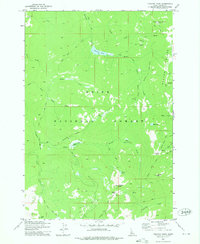
1973 Map of Chilcoot Peak
USGS Topo · Published 1975About this map
Riordan Pack Trail and other primitive routes weave through this high-elevation terrain within the Boise National Forest in the early 1970s. The landscape is defined by its drainage systems, with the North Fork and South Fork feeding into Bear Creek and Trapper Creek. Strategic points like the Riordan Lookout and summits such as Chilcoot Peak and Trapper Mtn provide orientation for those navigating the backcountry. High mountain basins hold small water bodies including Riordan Lake, Black Lake, and Chilcoot Lake. Transportation in this era relied heavily on non-motorized infrastructure, indicated by the Thunder Mountain Road (Pack) and the Summit Trail (Pack). Evidence of resource exploration appears at a Prospect located near Buck Creek, while natural landmarks like Pistol Rock and the wide openings of Trapper Flat offer distinct waypoints for surveyors and travelers alike.
Find a feature on this map
31 named features on this map. Tap any name to fly to it.
Don’t see what you’re looking for? This feature index may not catch every label — zoom into the map to look around manually.
Map Details
Editions of this 1973 Chilcoot Peak Map
This is the sole edition of this map. No revisions or reprints were ever made.
Other maps of this area

1937 · Yellow Pine
USGS Topo · 1:48,000

1943 · Yellow Pine
USGS Topo · 1:62,500

1954 · Warm Lake
USGS Topo · 1:62,500

1957 · Challis
USGS Topo · 1:250,000

1960 · Challis
USGS Topo · 1:250,000

1961 · Chinook Mtn
USGS Topo · 1:62,500

1963 · Challis
USGS Topo · 1:250,000
1973 · Big Chief Creek
USGS Topo · 1:24,000
1973 · Yellow Pine
USGS Topo · 1:24,000
1973 · Stibnite
USGS Topo · 1:24,000