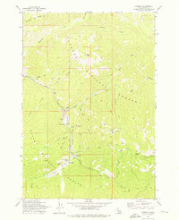
1973 Map of Stibnite
USGS Topo · Published 1976About this map
Mining operations and remote settlements define this high-elevation landscape in the Idaho backcountry during the early 1970s. The settlement of Stibnite serves as a central hub for the area’s industrial activity, surrounded by the extensive infrastructure of the Yellow Pine Mine, North Tunnel Mine, and Meadow Creek Mine. This survey documents a complex network of resource extraction, including prominent tailings and mine dumps near Cinnabar Peak. The presence of the Meadow Creek Landing Field and numerous Jeep Trails underscores the logistical challenges of operating in the steep drainages of the East Fork South Fork Salmon River.
Find a feature on this map
40 named features on this map. Tap any name to fly to it.
Don’t see what you’re looking for? This feature index may not catch every label — zoom into the map to look around manually.
Map Details
Editions of this 1973 Stibnite Map
2 editions found
Other maps of this area

1937 · Yellow Pine
USGS Topo · 1:48,000

1937 · Big Creek
USGS Topo · 1:48,000

1942 · Big Creek
USGS Topo · 1:62,500

1943 · Yellow Pine
USGS Topo · 1:62,500

1956 · Elk City
USGS Topo · 1:250,000

1957 · Challis
USGS Topo · 1:250,000

1960 · Elk City
USGS Topo · 1:250,000

1960 · Challis
USGS Topo · 1:250,000

1963 · Challis
USGS Topo · 1:250,000

1969 · Edwardsburg
USGS Topo · 1:24,000