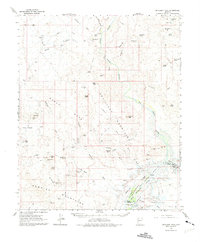
1966 Map of Artillery Peak
USGS Topo · Published 1975About this map
Mining claims and desert water sources define this mid-1960s landscape at the intersection of the Artillery Mountains and the Rawhide Mountains. The map documents a significant era of transition, with blue hatching indicating the area scheduled to be submerged by the future Alamo Reservoir, including portions of the Bill Williams River and the Big Sandy River. This inundation plan directly impacts historic river landmarks such as Bullard Crossing and Browns Crossing.
Find a feature on this map
65 named features on this map. Tap any name to fly to it.
Don’t see what you’re looking for? This feature index may not catch every label — zoom into the map to look around manually.
Map Details
Editions of this 1966 Artillery Peak Map
2 editions found

Other maps of this area

1923 · Signal
USGS Topo · 1:250,000

1942 · Signal
USGS Topo · 1:250,000

1950 · Prescott
USGS Topo · 1:250,000

1954 · Prescott
USGS Topo · 1:250,000

1958 · Prescott
USGS Topo · 1:250,000

1959 · Prescott
USGS Topo · 1:250,000

1960 · Prescott
USGS Topo · 1:250,000

1965 · Prescott
USGS Topo · 1:250,000
1966 · Swansea
USGS Topo · 1:62,500

1966 · Ives Peak
USGS Topo · 1:62,500