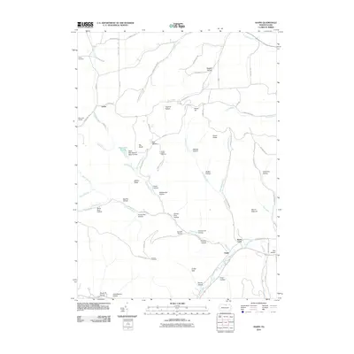
2010 Map of Asaph
USGS Topo · Published 2010About this map
The community of Asaph sits at the confluence of several vital watercourses, where Asaph Run and Marsh Creek meet at the foot of Mount Nesmuk. This 2010 survey of Tioga County reveals a landscape shaped by narrow valleys and high ridges, including the protected Black Ash Swamp Natural Area and the high point of Broad Ridge. Local industrial history is preserved at the Hessel Gesser Millstone site near Bear Wallow, while early aviation is represented by Sharretts Airport to the northwest. The terrain is deeply carved by countless named hollows such as Frying Pan Hollow, Spike Buck Hollow, and Scotch Pine Hollow, reflecting a nomenclature rooted in local wildlife and pioneering life. Near the southern boundary, the Goodall Fire Tower and Goodall Hollow mark a significant topographic overlook, while the Ackley Cemetery near Azelta provides a specific point of interest for those documenting family history in this part of Clymer Township.
Find a feature on this map
84 named features on this map. Tap any name to fly to it.
Don’t see what you’re looking for? This feature index may not catch every label — zoom into the map to look around manually.
Map Details
Editions of this 2010 Asaph Map
This is the sole edition of this map. No revisions or reprints were ever made.
Other maps of this area

1899 · Gaines
USGS Topo · 1:62,500

1900 · Gaines
USGS Topo · 1:62,500

1900 · Elkland
USGS Topo · 1:62,500

1946 · Tiadaghton
USGS Topo · 1:24,000

1946 · Antrim
USGS Topo · 1:62,500

1946 · Antrim
USGS Topo · 1:24,000

1947 · Galeton
USGS Topo · 1:62,500

1947 · Marshlands
USGS Topo · 1:24,000

1948 · Antrim
USGS Topo · 1:24,000
1948 · Tiadaghton
USGS Topo · 1:24,000