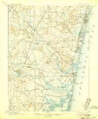
1901 Map of Asbury Park
USGS Topo · Published 1905About this map
The New Jersey shore at the turn of the century shows a sophisticated network of early transport and established coastal hamlets. Inland, the Pennsylvania Railroad and New Jersey Central Railroad intersect at Farmingdale, facilitating the movement of goods from rural outposts like Lower Squankum and Seven Stars toward the coast. The landscape is defined by its intricate waterways, from the Manasquan River to the broad reach of the Metedeconk River, where settlements like Osbornsville and Burrsville sit amidst the marshes.
Find a feature on this map
109 named features on this map. Tap any name to fly to it.
Don’t see what you’re looking for? This feature index may not catch every label — zoom into the map to look around manually.
Map Details
Editions of this 1901 Asbury Park Map
5 editions found

Other maps of this area

1884 · Whitings
USGS Topo · 1:62,500

1888 · Barnegat
USGS Topo · 1:62,500

1888 · New Brunswick
USGS Topo · 1:62,500

1888 · Asbury Park
USGS Topo · 1:62,500

1888 · Cassville
USGS Topo · 1:62,500

1888 · Sandy Hook
USGS Topo · 1:62,500

1888 · Whitings
USGS Topo · 1:62,500

1893 · New Brunswick
USGS Topo · 1:62,500

1893 · Sandy Hook
USGS Topo · 1:62,500

1893 · Asbury Park
USGS Topo · 1:62,500